|
SNSN web site
Geophysics at
Uppsala University
Department of
Earth Sciences,
Uppsala University
|
Kiruna region earthquakes, blasts and mining induced events
Earthquakes, blasts and mining induced events in this dataset from the Kiruna region, 2005-2022.
SNSN (2024)
|
The Kiruna dataset
| Citation: |
Swedish National Seismic Network (2024). Kiruna
region earthquakes, blasts and mining induced events [Data set]. Uppsala
University. https://doi.org/10.18159/KIR-EBI23 |
| Description: |
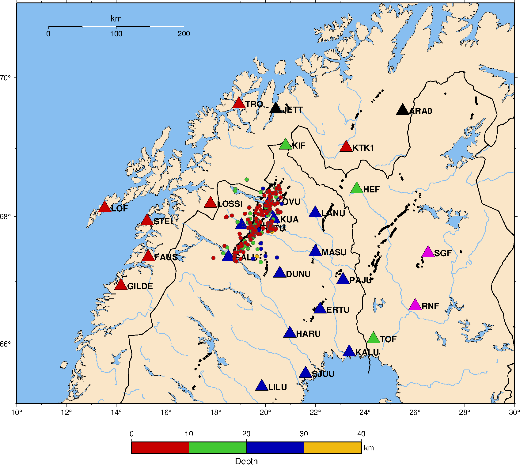
Data set of 189 earthquakes, 221 mining induced
events from the Kiruna mine and 221 blasts from the Kiruna mine, recorded by
seismic stations of the Swedish National Seismic Network (SNSN) and
neighbouring countries. The earthquakes are mostly located to the west of
Kiruna town, along the Pärvie post-glacial fault. The data contains event
information (origin time, latitude, longitude, depth magnitude), waveform
data, station information and instrument response information. |
| Keyword(s): |
earthquakes, mining induced, blast, Kiruna, Sweden |
| Related to: |
Rathnayaka, S., A.A. Nyblade, B. Lund, C. Ammon,
R. Durrheim, R. Masethe (2024). Testing the P/S amplitude seismic source
discriminant at local distances using seismic events within and surrounding
the Kloof gold mine, South Africa and the Kiruna iron ore mine, northern Sweden,
Bull. Seismol. Soc. Am., https://doi.org/10.1785/0120230215
Eggertsson, G., B. Lund, P. Schmidt, M. Roth (2024). Earthquake or Blast?
Classification of Local-Distance Seismic Events in Sweden using Fully-Connected
Neural Networks, Geophys. J. Int., https://doi.org/10.1093/gji/ggae018 |
| Location: |
Events in the Kiruna region in northern Sweden,
67.3 - 68.5 northerly latitude, 17.9 - 20.6 easterly longitude |
| License: |
This work is licensed under the non-commercial CC BY-NC 4.0 |
| Contact for more info: |
Björn
Lund at the Swedish National Seismic Network |
|
Download the data
Zip file with the full data set, 1.4 GB
|
| |
|
|
|